This consultation ended 10 May 2011.
Details of outcome
Summary of responses , file type: PDF, file size: 120 KB

Full responses , file type: PDF, file size: 4 MB
Original consultation
This consultation focuses on how we should approach marine planning in Wales and what we need to consider when drawing up the marine plans.
Consultation description
This consultation seeks views on how we intend developing marine planning in Wales in line with our powers and responsibilities under the Marine & Coastal Act 2009.
The consultation sets out our intention to develop a national plan for the Welsh inshore area and a national plan for the Welsh offshore area and adopt them by 2012/13. The consultation also sets out options for and asks questions on how we should plan on a sub-national level to embed more detail into the national plans.
This consultation document:
- maps key existing and planned economic environmental and social features resources and activities in Welsh seas and establish the need to consider them all in developing marine plans;
- sets out our overall vision for achieving sustainable development in Welsh seas;
- emphasises our commitment to make marine and land based planning joined up and seeks views on the challenges;
- provides the background to marine planning in Wales;
- explains the relationship between the UK Marine Policy Statement and Welsh marine plans;
- sets out the constitutional and administrative arrangements that will apply;
- proposes national plans and approaches to sub-national planning;
- outlines the cross-border planning relationships;
- commits to full public engagement and consultation and sets out the principles we will follow to achieve this; and
- outlines next steps.
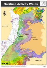
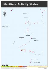
Maritime activity Wales
A Maritime activity map of Wales is available below either with or without layers. In the “with layers” document you can turn on or off layers of information. It is a large file and may take some time to download. The “without layers” document is a considerably smaller file.
Consultation documents
Consultation document , file type: PDF, file size: 410 KB
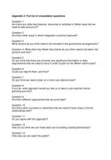
Full list of consultation questions , file type: PDF, file size: 14 KB
Maritime activity Wales (without layers) , file type: PDF, file size: 143 KB